

Open User Map
Turn your static WordPress map into a living community hub where visitors add and edit locations, growing with every contribution.
tool Details
Explore More
Alternatives
About Open User Map
Open User Map is a powerful and intuitive WordPress plugin that transforms your website into an interactive, community-driven mapping platform. At its core, this tool allows you to create a map that your visitors can actively contribute to, enabling them to add, edit, and manage locations directly from the frontend of your site. What makes Open User Map truly remarkable is its simplicity: there is no coding required, no need for a Google Maps API key, and no complex setup process. It is designed for anyone from small business owners and local community organizers to large tourism boards and event planners. The main value proposition is democratizing map data collection. Instead of relying on a single administrator to populate a map, you empower your users to share their knowledge, whether that means pinning their favorite local coffee shop, reporting a trail condition, or marking a point of interest on a conference floor plan. Every submission goes through an approval workflow, ensuring that only accurate and appropriate content goes live. With over 15,000 active installs and a perfect 5-star rating, Open User Map has proven itself as a reliable, user-friendly solution. It evolves with your needs, offering a free version to get started and a PRO version that unlocks advanced features like custom images as maps, advanced filter interfaces, and community rating systems. This plugin grows with your project, from a simple location directory to a complex, multi-faceted interactive experience.
Features
Frontend Location Submissions and Editing
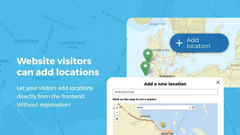
Allow your website visitors to add and edit locations directly on your map without any backend access. By clicking an Add location button, users can place a marker and submit detailed information through a customizable form. Every new submission enters an approval workflow, giving you full control over what becomes public. The editing capability lets users update their existing locations, ensuring the map always reflects the most current information. This feature turns your map into a living, breathing resource that improves over time through community contributions.
Lines and Areas for Complex Mapping
Go beyond simple point markers by adding routes, paths, zones, and regions directly to your map. The Lines and Areas feature allows you to highlight trails, service areas, event grounds, neighborhoods, construction zones, or any custom shape that helps visitors understand your map at a glance. Distances and area sizes are calculated automatically, so routes and polygons can include helpful measurements right out of the box. This is essential for maps that need to convey spatial relationships, such as hiking trails or delivery service boundaries.
Custom Image as Map
Upload any image and transform it into a fully interactive map. Whether it is an overlay, floor plan, event layout, game map, product diagram, campus guide, or seating chart, this feature allows users to place markers directly on top of the image with the same powerful functionality as a traditional map. You can add locations, display custom fields, enable filtering, and create an engaging, clickable experience tailored exactly to your use case. This opens up endless possibilities for non-geographic mapping scenarios.
Advanced Filter Interface
Create a filter sidebar that appears next to your map, allowing visitors to filter locations by any custom field you have configured. You can also add custom HTML content sections to display additional information or branding. This gives users a clearer, more intuitive way to explore your mapped data. For example, a restaurant directory can allow users to filter by cuisine type, price range, or opening hours. The advanced filter interface transforms a static data display into a dynamic exploration tool.
Use Cases
Community-Powered Local Business Directory
Create a map where residents can add and review local businesses, from coffee shops and restaurants to hardware stores and gyms. Users submit locations with details like address, phone number, and website. The approval workflow ensures quality control. The star rating and upvote features let the community highlight the best places. This turns your website into the go-to resource for discovering what is great in your neighborhood, evolving from a simple list into a trusted community guide.
Event Venue and Conference Planning
Use the Custom Image as Map feature to upload a floor plan of a conference center, festival grounds, or trade show. Allow attendees to place markers for their booths, sessions, or meetup points. The Lines and Areas feature can highlight walkways, restrooms, and emergency exits. The advanced filter interface lets attendees filter by session type, sponsor level, or activity zone. This creates an interactive guide that enhances the attendee experience and reduces the burden on event staff.
Tourism and Travel Guide
Build a comprehensive travel map for a city or region. Visitors can contribute points of interest like hiking trails, scenic viewpoints, historic landmarks, and hidden gems. The Regions feature can designate neighborhoods or districts, making it easy to explore different parts of a city. The opening hours custom field type, complete with a live Open Now indicator, is perfect for listing local shops and restaurants. This map evolves as new places are discovered, always staying fresh and relevant.
Educational Campus and Facility Maps
Create an interactive map for a university campus, hospital, or corporate office park. Upload a custom image of the campus layout and allow students, staff, or visitors to add markers for buildings, departments, parking lots, and key amenities. The approval workflow ensures only official locations are published. The filtering interface lets users find specific buildings or services quickly. This reduces confusion for newcomers and creates a centralized, user-maintained resource.
Pricing
Open User Map offers a free version available on WordPress.org with core features like frontend submissions, approval workflows, and basic customization. For users who need advanced capabilities, the PRO version unlocks features such as Custom Image as Map, Lines and Areas, Advanced Filter Interface, Upvotes and Likes, Star Ratings, Opening Hours, and Regions. You can start a 7-day free trial of the PRO version with no credit card required and no automatic conversion to a paid subscription. Specific pricing for the PRO version is available on the Open User Map website.
Frequently Asked Questions
Do I need a Google Maps API key to use Open User Map?
No, you do not need a Google Maps API key. Open User Map uses OpenStreetMap data by default, which is free and does not require any API key. This eliminates a major barrier to entry and ongoing cost for many website owners. You can still use Google Maps if you prefer, but it is not required for the plugin to function.
Can I moderate submissions before they appear on the map?
Yes, absolutely. Open User Map includes a built-in approval workflow. When a visitor submits a new location or edits an existing one, the submission goes into a pending queue. You can review the details, approve or reject the submission, and only approved locations will be published on the map. This gives you full control over the quality and accuracy of the content.
Is it possible to customize the submission form fields?
Yes, you can fully customize the submission form using the flexible custom fields feature. You can add text boxes, links, checkboxes, dropdowns, and more. This allows you to gather exactly the information you need from users, such as a description, phone number, website, or category. You can also make certain fields required or optional, tailoring the form to your specific use case.
Can I use Open User Map with a custom image instead of a geographic map?
Yes, the Custom Image as Map feature allows you to upload any image, such as a floor plan, seating chart, or event layout, and turn it into a fully interactive map. Users can place markers on the image, fill in custom fields, and filter locations just like on a geographic map. This is perfect for non-geographic mapping scenarios.
Similar to Open User Map
Grabclip
Free, ad-free downloader for video & audio from YouTube, TikTok, Instagram, X, Reddit & more — up to 12K, 320kbps MP3.

Built2Win AI Indexing
AI‑ready websites, WebAgentScan SaaS, and Indexing Pack. MCP, A2A, llms.txt — hand‑coded PHP, complete ownership, flat‑fee, free quote.

Webleadr
Webleadr empowers you to effortlessly find and contact businesses without websites, transforming leads into clients in just a few clicks.

Idearium
Idearium crafts impactful websites that drive growth and tell your unique story, ensuring memorable digital experiences.

FilexHost
FilexHost evolves your file sharing from simple uploads to powerful, secure hosting for any project.

Crawlkit
CrawlKit evolves your data extraction from complex scraping into a single, simple API for any website.
Best Boilerplates
Find and compare top SaaS boilerplates to launch your app faster with the right features and tech stack.

Shadcn UI Kit
Accelerate your development with the Shadcn UI Kit's pre-built dashboards, templates, and components for React.